|
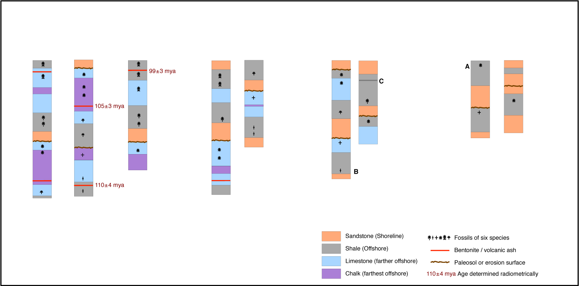
UGA GEOL 1122 stratigraphy exercise Overview: This page presents an exercise to illustrate stratigraphic concepts to beginning geology students, with very preliminary considerations of biostratigraphy, lithostratigraphy, and chronostratigraphy. One of its goals is to answer the question "How can geologists claim to know the age of a rock or fossil without having a radiometric age for that specific rock or fossil?". The page presents materials for the project and directions about how to proceed, and then it presents the results, so that students can evaluate their work. The conceptual introduction required to complete the project is in Railsback's GEOL 1122 lecture on "correlative and relative dating". Materials for the project: The panel just below has nine very simple stratigraphic sections, or logs from observations of outcrops. The nine sections are arranged horizontally with their spacing proportional to the distances between outcrops. The sections are arranged vertically simply with their tops on one horizontal line. Thus, as students work with the sections to correlate them, the logs will be moved up and down by the students, but the spacing of sections horizontally need not be changed. Each section shows the vertical sequence of strata present in the outcrop. Only four kinds of rock are considered: sandstone, shale, limestone, and chalk, which for the purposes of this exercise are assumed to be deposited from shorelines to far offshore in that lateral order. In addition, layers of volcanic ash (bentonite) are indicated where they are present, and radiometric ages are given for three specific occurrences of such material. Occurrences of specimens of six species of fossils are also shown on the sections.
|
|
Directions: Step 1: Correlate the sections biostratigraphically to make a cross-section. This requires moving the logs vertically so that similar fossils are found in the same levels. Students more comfortable working with paper can print the panel of sections on paper, cut out the individual sections as separate pieces, move the sections as needed, and then affix the pieces to an underlying blank sheet of paper. Students more comfortable working with computers can import the images of the sections into graphics programs like Photoshop, Illustrator, or Draw and arrange the sections therein. One good product from Step 1 is shown in the Results farther down this page.
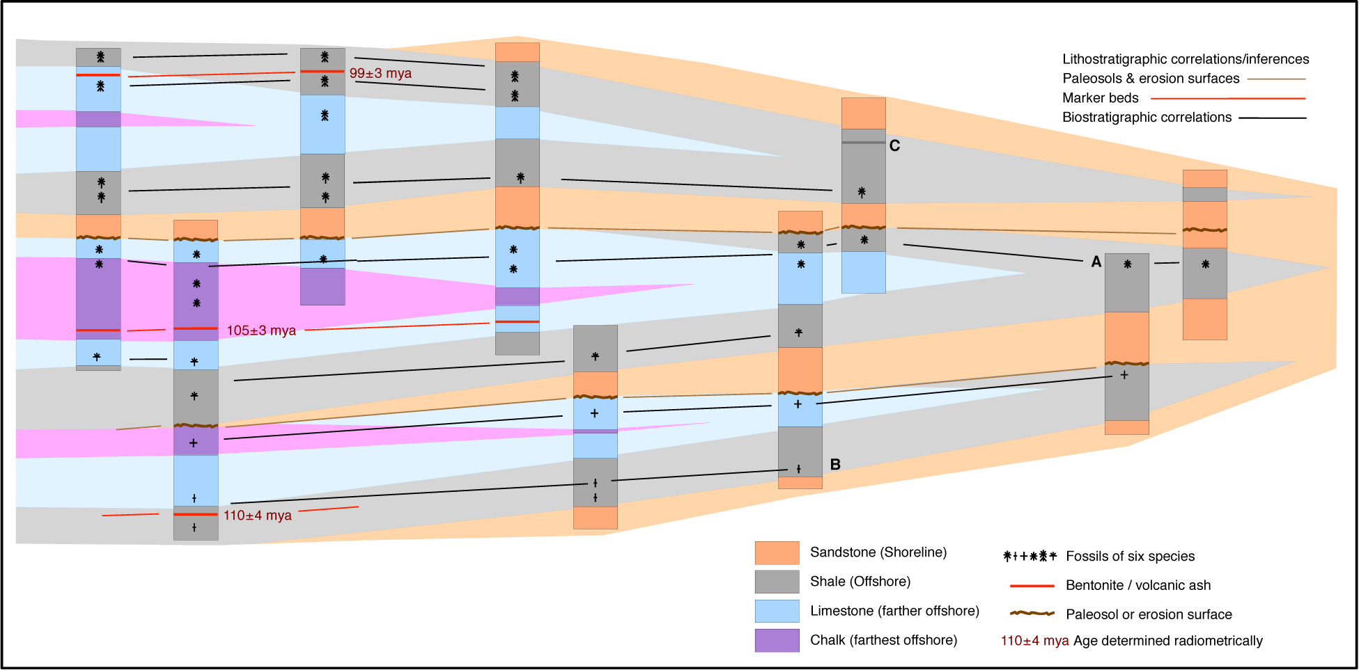
Step 2: On your product from Step 1, correlate the marker beds (the deposits that should have deposited over large areas in a short period of time). One good product from Step 2 is shown in the Results farther down this page.
Step 3: On your product from Step 2, correlate the paleosols and surfaces of erosion, which record times of non-deposition or erosion. One good product from Step 3 is shown in the Results farther down this page.
Step 4: On your product from Step 3, make lithologic correlations, joining together volumes of rock of the same kind. You may want to use the orange, gray, blue, and magenta shadings to indicate kinds of rock, rather than drawing more lines on your cross-section. One good product from Step 4 is shown in the Results farther down this page.
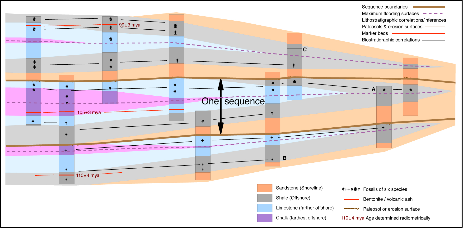
Step 5: On your product from Step 4, mark the unconformities and label the one complete sequence that is evident on your cross-section. Also mark the maximum flooding surface(s). One good product from Step 5 is shown in the Results farther down this page.
Step 6: Answer the following questions: Which way (to the left or right) was landward, and which way was seaward? How many cycles of rising and falling sea level are evident from your cross-section? During which geologic period were the sediments in this cross-section deposited? How old is the fossil labeled "A"? How old is the fossil labeled "B"? How old is the layer of rock labeled "C"? Comparing the strata above the three chalks, why is there limestone and shale above the chalk in the uppermost cycle, just limestone above the chalk in the middle cycle, and neither limestone nor shale above chalk in the lowermost cycle? Why is no fossil species found both below and above an unconformity or sequence boundary?
XXXXXXXXXXXXXXXX - - - RESULTS - - - XXXXXXXXXXXXXX
|
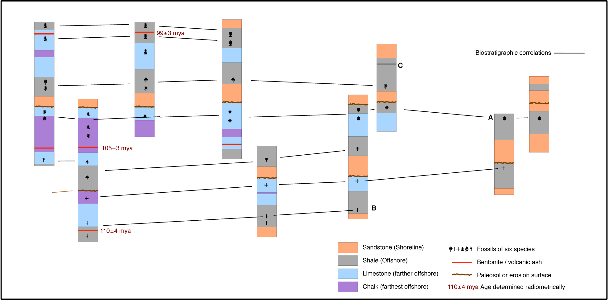
You can click on this image to access a larger version.
Different interpretions agreeing with regard to correlations will nonetheless have slightly different overall geometries, so that
some cross sections may slant more upward or more downward from right to left. The correlations are important; the angles are not.
Step 2:
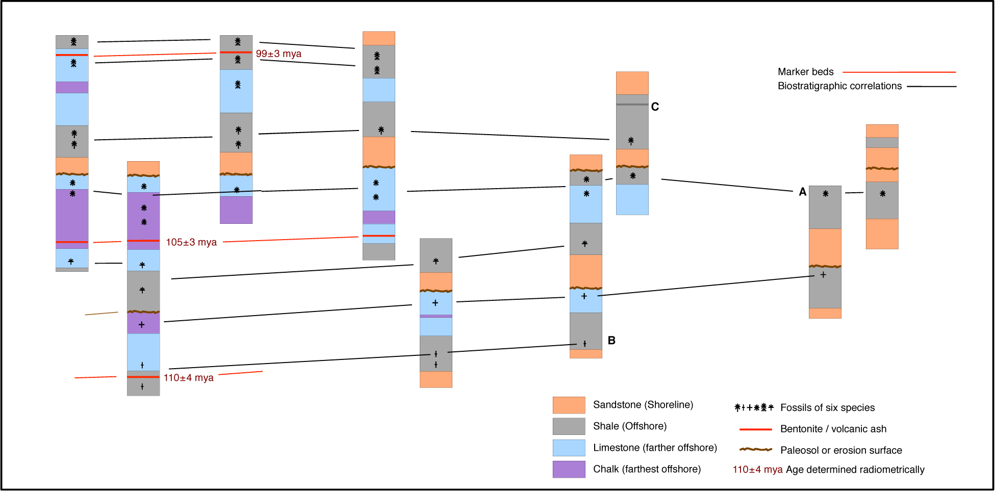
You can click on this image to access a larger version.
Step 3:
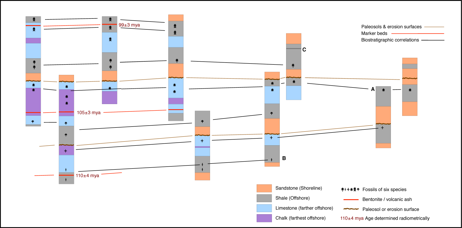
You can click on this image to access a larger version.
Step 4:
You can click on this image to access a larger version.
Step 5:
You can click on this image to access a larger version.
|
Step 6 Which way (to the left or right) was landward, and which way was seaward? Landward was to the right (the direction of the sands, derived from land) and seaward was to the left (the direction of the chalk, deposited in deepest water).
How many cycles of rising and falling sea level are evident from your cross-section? There are three, evident two ways: (1) the three vertical sequences with chalk in the middle, because chalk represents the deepest-water enviroment and thus the highest sea level, and (2) the three cycles of facies shifting to the right (landward) and then back to the left.
During which geologic period were the sediments in this cross-section deposited? The Cretaceous. Comparison of the radiometric ages with the geologic time scale requires that the period be the Cretaceous. More generally, Earth's lack of chalks in older strata and the abundance of chalk in Cretaceous strata also make a Cretaceous age for this example a likely inference, even if we had no radiometric ages.
How old is the fossil labeled "A"? It appears to be about 103 or 104 m.y. old, as suggested by the biostratigraphic correlations leftward from A to the region where there are radiometric ages.
How old is the fossil labeled "B"? It appears to be about 110 m.y. old, as suggested by the biostratigraphic correlations leftward from B to the region where there are radiometric ages.
How old is the layer of rock labeled "C"? It appears to be about 100 m.y. old, as suggested by the biostratigraphic correlations leftward from C to the region where there are radiometric ages. Note that there are no radiometric ages for A, B, and C, but we can estimate their ages thanks to biostratigraphic correlation.
Comparing the strata above the three chalks, why is there limestone and shale above the chalk in the uppermost cycle, just limestone above the chalk in the middle cycle, and neither limestone nor shale above chalk in the lowermost cycle? Erosion cut down more extensively during the lowstand of sea level between the first and second cycles, not quite as far down during the lowstand of sea level between the second and third cycles, and still less far down during the lowstand of sea level after the third cycle.
Why is no fossil species found both below and above an unconformity or sequence boundary? Each of the sequence boundaries (the collective paleosols and erosion surfaces) represent time that is not represented by rocks and fossils in this section: during that time, there was deposition of sediment subsequently eroded, or there was erosion. These missing time intervals may be sufficiently long to make survival of a species across that time interval unlikely.
Final comments: Note that none of the time lines that we drew in Steps 1, 2, and 3 cross each other. By definition, they shouldn't, because crossing of two lines that each synchronous events would mean a reversal of older-younger relationships, or a temporal paradox. Final caveats: The facies model used here, of sandstone-shale-limestone-chalk from land to deep sea, is not necessarily the case everywhere - it's just a simple model to make a simple exercise. Paleosols are commonly not present and erosion surfaces are commonly not obvious. In many cases, unconformities have to be inferred not from obvious evidence like paleosols and erosional scouring but only from the position of unlikely sedimentary rocks over others. An example would be the sandstone-over-chalk or sandstone-over-limestone relationships at the left side of our cross-section, which raise the question "How were nearshore sediments deposited on top of far-offshore sediments?" The answer would be that the nearshore sediments weren't deposited on top of far-offshore sediments immediately after the deposition of the far-offshore sediments. Instead, a lot of time passed in which sea level fell and in which sediments overlying the far-offshore sediments were eroded. Please keep the context of this exercise in mind. For introductory students, it will commonly be a challenging exercise that will hopefully expand such students' thinking about the geologic record. For advanced students a year or two further along in their education, it will be a strikingly easy exercise with many over-simplifications. It should be used by, or assigned to, introductory students, but it should not be assigned to, or used as a guide for interpretation by, advanced students for whom its simplifications can become pitfalls.
e-mail to Bruce Railsback (rlsbk@gly.uga.edu) Railsback's main web page UGA Geology Department web page
The content and opinions expressed on this Web page do not necessarily reflect the views of nor are they endorsed by the University of Georgia or the University System of Georgia.
|