|
This virtual field trip takes us to a fault in the Lost River Mountains north of Arco, in east-central Idaho. If you've been on our field trip to the Moab Fault, this will be a bit trickier, in that we won't have a roadcut of a US highway to expose our suspect, and we won't have thousands of feet of offset in a famously well-known stratigraphic section. But that's the fun of it.
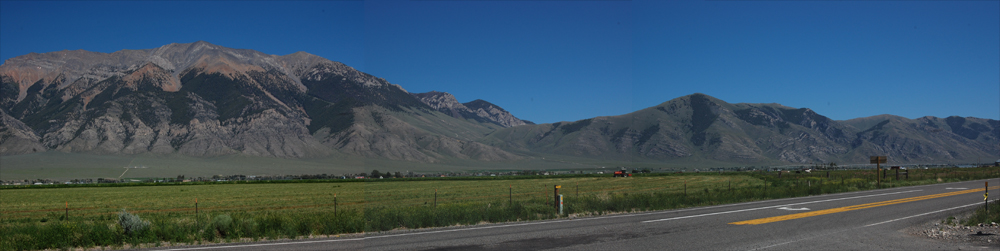
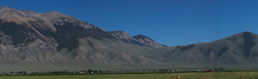
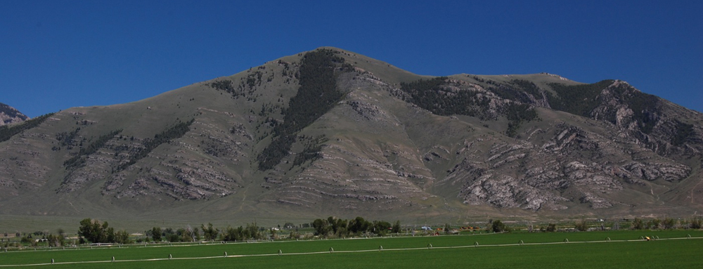
Let's start by driving south down U.S. Highway 93 in the Lost River Valley, and pulling off at the mouth of Antelope Valley to look east at the Lost River Mountains. From left to right, we're looking at the southern flank of King Mountain, Beaverlands Pass, and the northern flank of unnamed small mountains that make up the southern end of the Lost River range:
|
Image 1
|
|
|
Image 2
|
|
|
You can also view a 4179-pixel-wide 700-pixel-high version of the 1000-pixel-wide 251-pixel-high image above. It will open in a new window, so you won't have to reload this page to get back. You'll probably have to scroll from left to right on the large version of the image. |
|
|
|
Alternately, we can look at the following three images, taken from three different vantage points. The first is of King Mountain, the mountain on the left above; the second is Beaverlands Pass, in the middle on the image above ; and the third is the low mountains that are on the right in the image above. Thus these three images, from top to bottom, provide a different perspective on the image from right to left above.
|
|
Image 3 (King Mountain, on the left in Image 2)
|
|
|
Image 4 (Beaverlands Pass from the west)
|
|
|
Image 5 (Low mountains to right in Image 2)
|
|
|
|
|
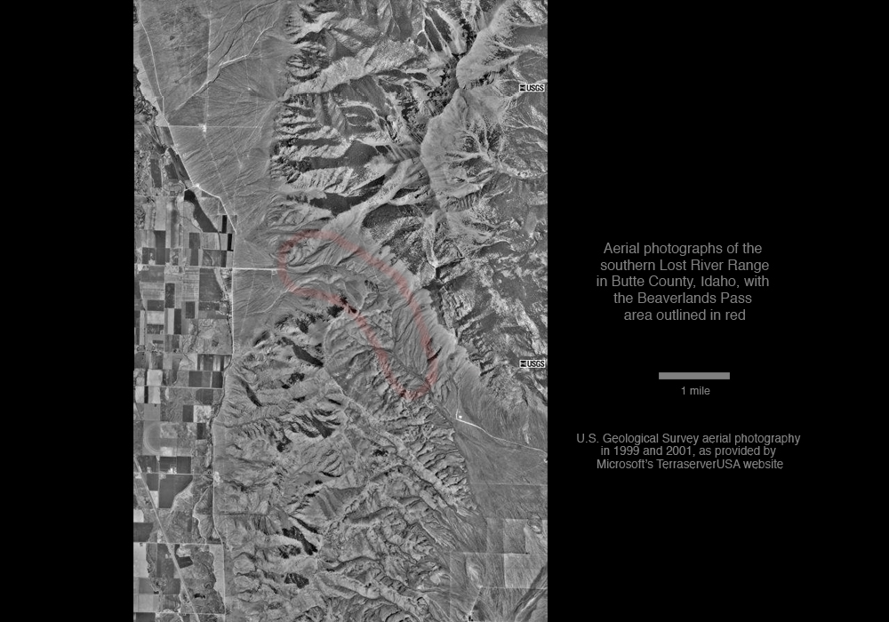
Here are aerial photographs giving a birds-eye view of the area shown above, with Beaverlands Pass outlined in faint red:
|
|
Image 6a - Aerial photographs
|
|
|
|
|
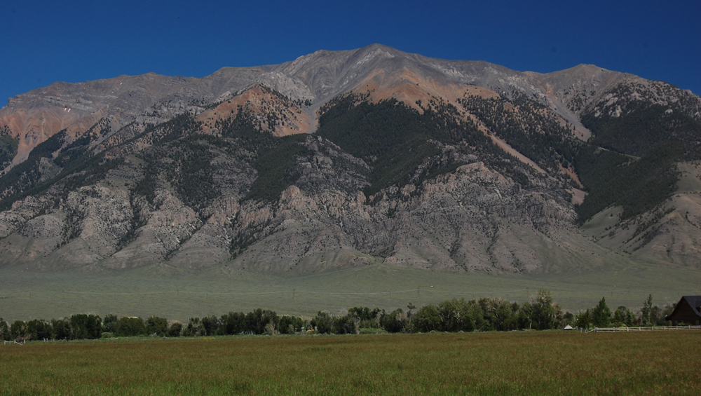
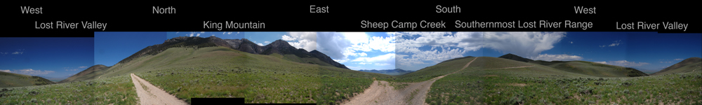
For a very different perspective, we can go up to the summit of Beaverlands Pass and make a 360° rotation, so that we see the panorama below. The panorama confirms the differences that we've seen in Image 2, in that we see layered limestone cliffs on the flank of King Mountain north of the pass and rounded hilltops to the south:
|
|
Image 6b - a panorama from the summit of Beaverlands Pass
|
|
|
You can also view a 5815-pixel-wide 700-pixel-high version of the 1000-pixel-wide 251-pixel-wide image above. It will open in a new window, so you won't have to reload this page to get back. You'll probably have to scroll from left to right on the large version of the image.
|
|
|
|
So have you reached any conclusions from seeing this drive-by geology? We've seen two very different landscapes, one a high mountain and the other low mountains or at most hills, on each side of a valley that separates them. The high mountains have a low mantle of layered rocks but reach up to distinctly red-brown-weathering rocks at the upper tree line and then gray layered rocks above that. The low mountains on the right consist entirely of layered rocks that dip in directions unlike those seen on the north side of the valley between. The layered rocks high to the left of Beaverlands Pass and in the low mountains to the right of the pass are Mississippian-age limestones.
|
|
|
|
In short, we see considerably different geology on each side of a valley. If we consider that fault zones commonly are weathered and eroded to produce valleys, our Beaverlands Pass valley in the middle of Image 2 looks like it might be the topographic (surface) expression of a fault.
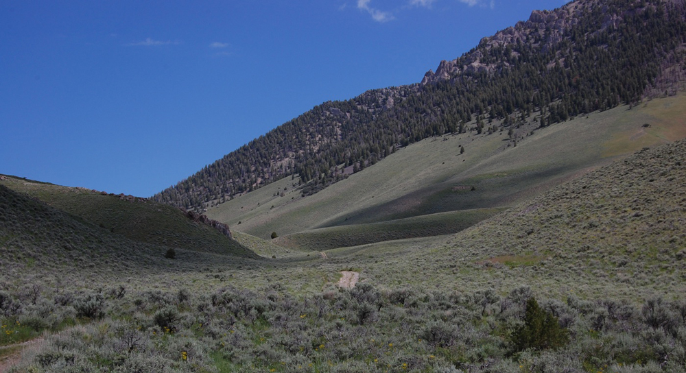
To put that a bit more scientifically: we might hypothesize that Beaverlands Pass is the topographic expression of a fault. Thinking scientifically, we would then want to test that hypothesis by seeing if other characteristics of a fault are present in Beaverland Pass. For example, we could look for a fault breccia, the rock broken up along a fault. With that in mind, let's go up Sheep Camp Creek, the generally dry east approach to Beaverlands Pass:
|
|
Image 7
|
|
|
|
|
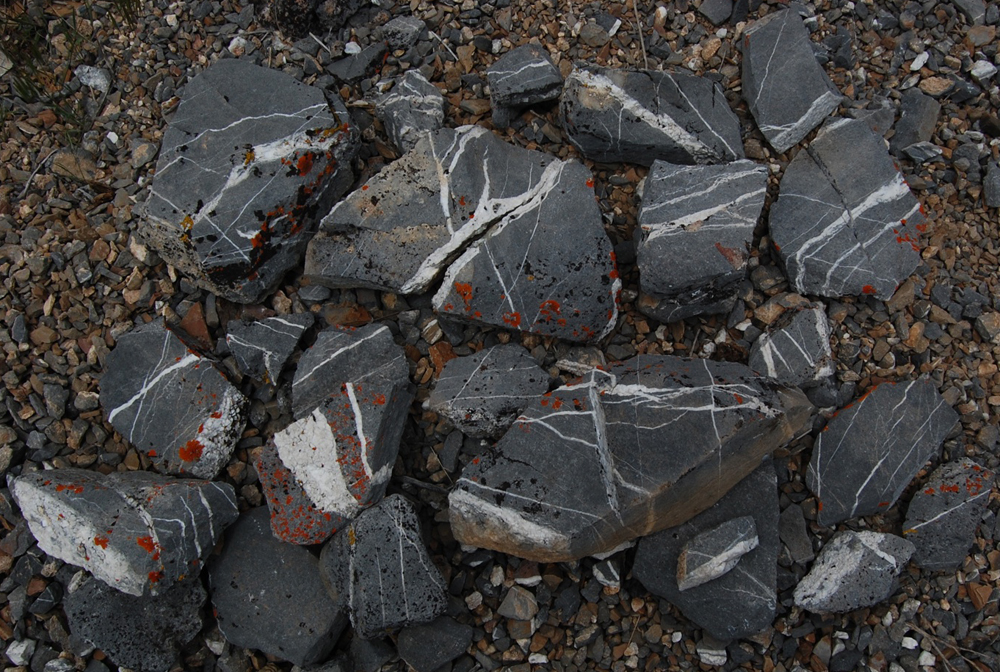
Here's a highly selective collection of pieces from the float (the loose no-longer-bedrock rocks) on the flanks of Sheep Camp Creek east and down from Beaverlands Pass:
|
|
Image 8
|
|
|
|
|
In the image above, we're looking at pieces of dark-gray limestone that have been broken up (brecciated), and in which white calcite has precipitated from groundwaters passing through the resulting cracks or fractures. This is the sort of breccia one would expect to find in the vicinity of a fault, and so it supports our hypothesis of a fault. In fairness, limestone is a brittle rock that can fracture after relatively little deformation, so some fractured limestone would not be overwhelming evidence of a fault of any significance. However, the intensity of the fracturing here (note the many cross-cutting factures) and abundance of fractured float suggest that we are indeed at a fault.
|
|
|
|
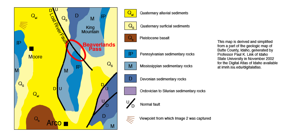
At this point, we seem to have found some evidence to support our hypothesis of a fault at Beaverlands Pass. Of course, detailed field mapping is what's required to establish the existence of a fault. That sort of mapping underpins a map like the one below:
|
|
Image 9
|
|
|
|
|
This map not only supports our idea of a fault at Beaverlands Pass but also suggests that rocks to the north moved up and/or rocks to the south moved down, which is compatible with the Mississippian limestones that we see high on the flanks of King Mountains and low on the flanks of the low mountains or hills south of Beaverlands Pass.
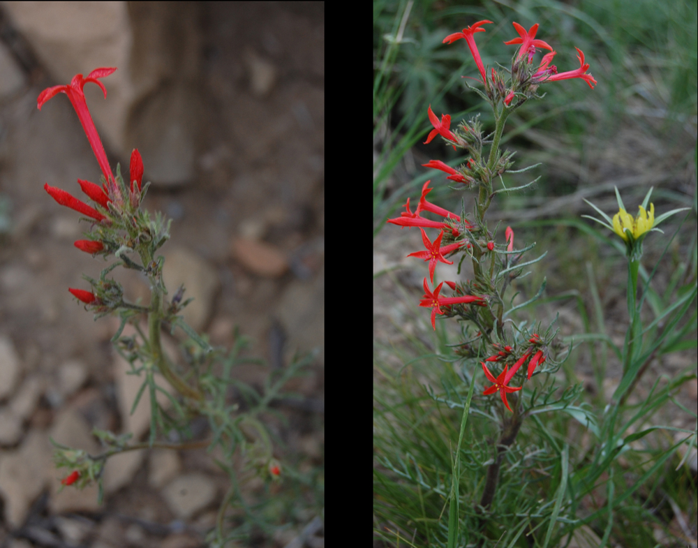
So . . . we seem to have indeed found a fault. Let's celebrate by ending our trip with a non-geologic treat, a view of a scarlet gilia of the sort growing east of Beaverlands Pass:
|
|
Image 10
|
|
|
|