|
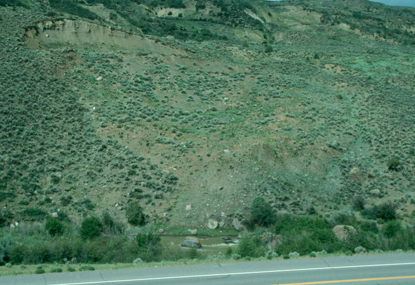
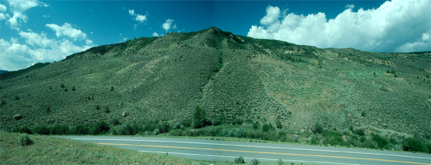
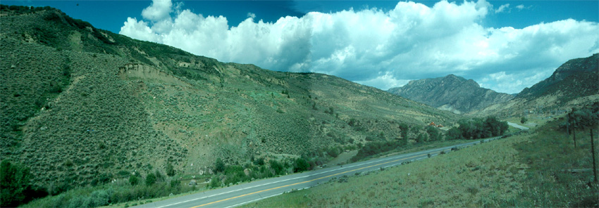
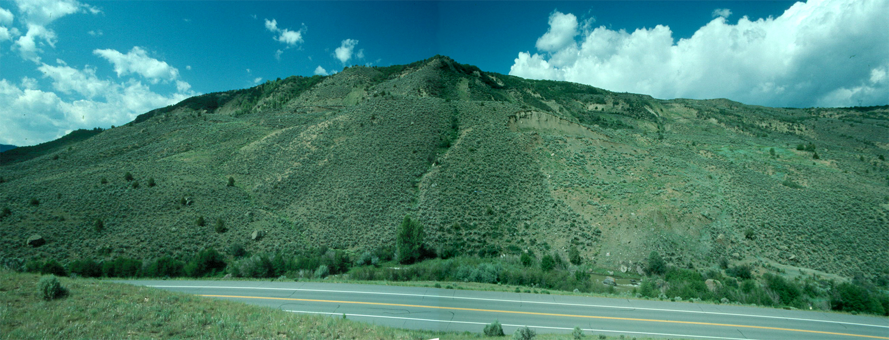
We're standing along U.S. Highway 50 about a mile east of the small town of Cimarron, west of Gunnison in western Colorado. We're looking west across the highway and across the Cimarron River to the hillside opposite us, and we're looking at . . . well, what are we looking at in the image below?
|
|
|
|
|
|
|
So what do we see? At the upper left is a curving scarp or small cliff that is concave in the downslope direction. The middle of the field of view is an area that seems a little lower than the areas to its right and left, and with vegetation that has a different pattern - more scattered and diffuse - than the area to its right and left. Downslope and to the lower right, but still above the stream, is a hummocky area of loose debris. So what does all that tell us?
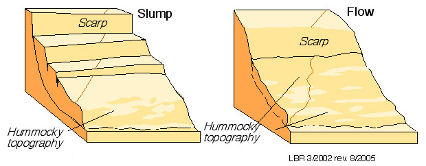
What we've just described provides all the hallmarks of a landslide. As the sketches below illustrate, landslides often move sufficiently as a unit that they leave behind a gap in the landscape at their top end, and thus a scarp. At their downslope end, they have to overrun the slope below the landslide, so there's commonly a rumpling of their lower end or a piling of debris. Slumps and flows, as shown below, are two kinds of landslides, and our landslide above seems to be something in between, though perhaps more toward the flow end of the spectrum.
|
|
|
|
|
|
|
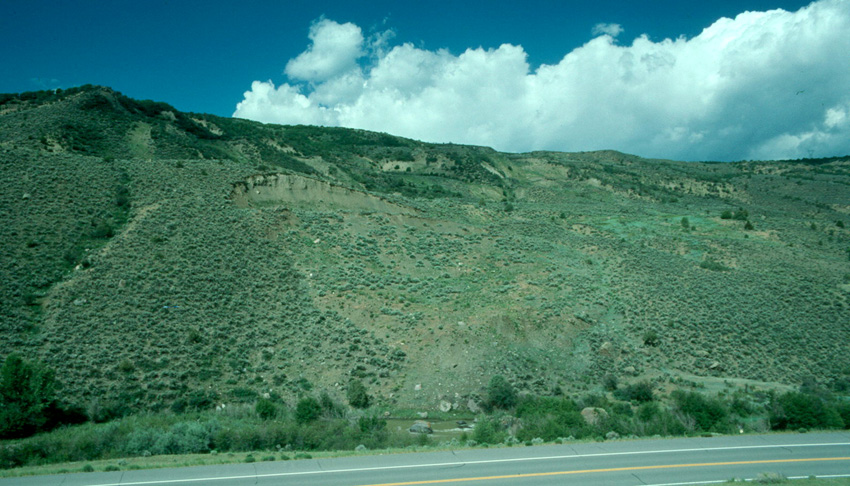
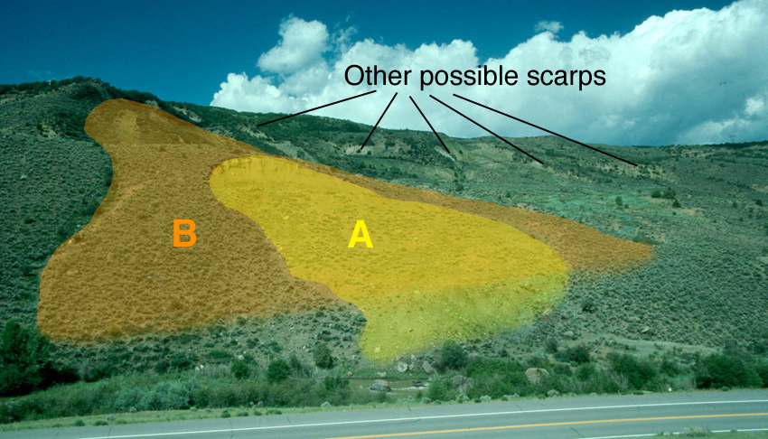
So we've found ourselves a landslide, which we'll call "Landslide A". Let's back up and take in some more of the view. What do you see here?
|
|
|
|
|
|
|
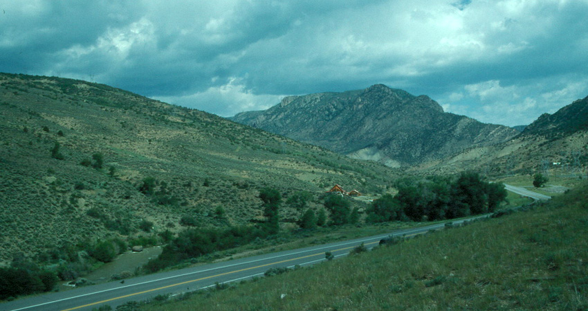
Above and to the left of our previous scarp, and thus in the upper left of this image, there's a peculiar steep curving slope near the top of the hill. It looks like our previous scarp, but rounded off and covered with a little vegetation. Down the left side of the image is a sharp boundary in the vegetation, and the area to the right is recessed into the hillside just a little relative to the leftmost area in the image. What does that tell us?
It appears that we've indentified another, and larger, but older, landslide. It has a scarp, albeit one modified by time, it has a sharp lateral margin, and it has a depressed mid-section. We can't recognize a lower bulge or rumpled zone, but the stream may have removed much of that.
So, we've found a landslide, the fresher one that we found first, that has formed on and in an older landslide! That's the reason for this trip's title of "A Landslide's Landslide". We called the fresher example "Landslide A", so let's call the older one that we just found "Landslide B".
With that in mind, look across the image above for any other evidence of landslides. See anything, especially up toward the skyline?
|
|
|
|
|
|
Once one starts looking for them, more possible scarps become evident below the skyline in the image above. If you don't see them, or if you're not sure you've seen A and B, you can look at a marked image
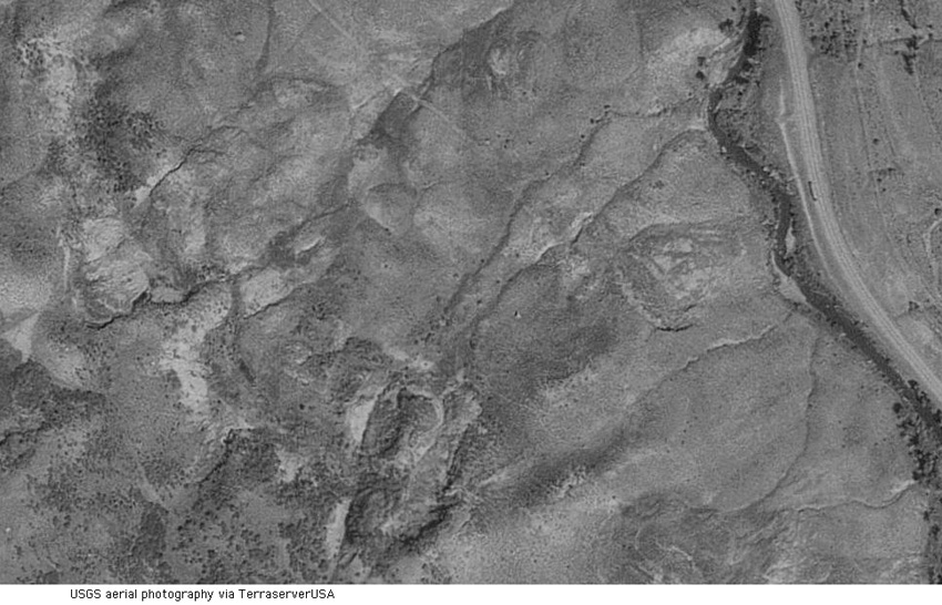
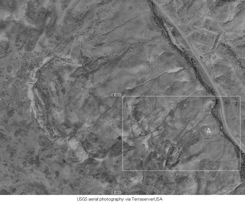
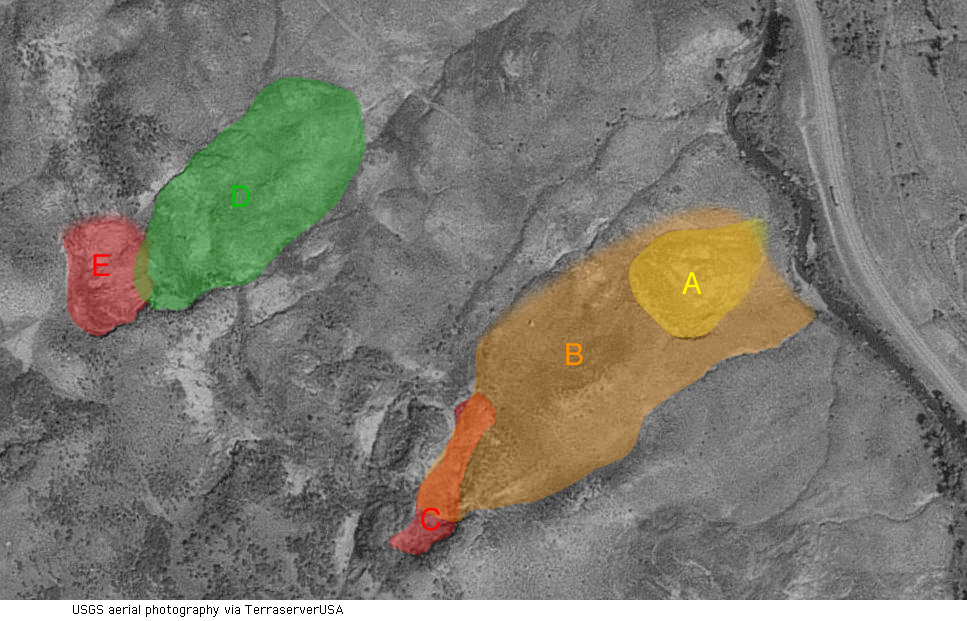
With that in mind, let's get a bird's eye view of things. The US Geological Survey has produced aerial photographs of the entire United States, and we can use those to take a look here. In the image below, the highway and stream that we've being seeing in the foreground are at the right side, and we've been standing to the right of the road and looking toward the left side of the aerial photograph. See anything?
|
|
|
|
|
|
|
In the image above, our Landslide A is at the center-right. Landslide B extends from the lower center to the right center. More landslides are evident as well - you can look at a marked image to see three more landslides (C, D, E) labeled, and in fact more are evident between B and D, and northwest of D. The entire area west of the stream is landslides!
But wait - there's more! If we look at aerial photography of a larger area, as in the image below, even more of the area emerges as landslides. The area of the image above is enclosed by the gray rectangle in the image below. Note the C-shaped white feature in the left side of the image below - its a huge scarp compared to Landslide A with which we began.
|
|
|
|
|
|
|
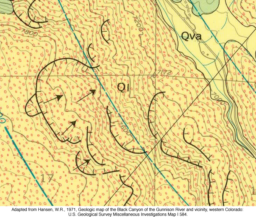
If you're skeptical of all this identification of landslides from the air, here's a US Geological Survery map of the same area as in the image just above. The yellow field dotted with red circles and lablel "Ql" is all Quaternary-age landslide deposits. The bold black lines with perpendicular ticks are scarps at the tops of individual landslides.
|
|
|
|
|
|
|
|
|
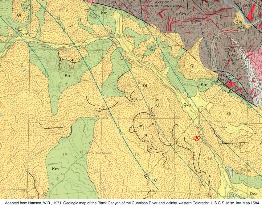
In fact, to get any sense of what's not landslide, you have to back up to the level of observation shown below. Our original Landslide A is shown for comparison at right. The squares in the map are one-mile squares, so the image represents more than three miles from east to west.
|
|
|
|
|
|
|
In the image above, the green areas labeled "Km" are where the Cretaceous-age Mancos Shale is the bedrock and does not appear to have slid. All the yellow-with-red area labeled "Ql" is landslide deposits generated by failure of the Mancos Shale. Shales are not strong rocks, and they commonly weather to form slopes rather than resist erosion to form cliffs and outcrops. However, the Mancos is exceptionally weak here and has repeatedly given way to give landslides across most of its area of exposure.
|
|
|
|
Let's get back on the ground for a couple of last looks. First, let's scan from our original Landslide A at right below across our older Landslide B and onward to the left, where we haven't look before. What do you see?
|
|
|
|
|
A larger 1830 x 700 version of this image
|
|
|
|
By now, you should see the bulging landscape near the road and steeper slopes above, and therefore suspect landslides and scarps. Let's swing to the right for a look, as in the image below.
|
|
|
|
|
A larger 2113 x 700 version of this image
|
|
|
|
And we can close in for a closer look to the right, as in the image below. What do you see?
|
|
|
|
|
|
|
To the left of the highway, you should again see landslides. Here they constrast nicely with the rugged slopes of the mountains of hard Precambrian crystalline rocks in the distance. Also note the reddish brown house that sits at the toe of the landslides.
Hopefully you've by now gotten some experience at recognizing landslides. So who cares? The answer is obvious in the image above. Anyone buying or building a house at the toe of a landslide should care, because that house can be overrun by, or carried along with, a landslide. Hopefully you'll only profit from this trip by better understanding the landscapes you see in your travels, but you may also avoid a costly mistake by knowing a little more about hazards like landslides.
|