A Virtual Field Trip to the Moab Fault near Moab, Utah, U.S.A.

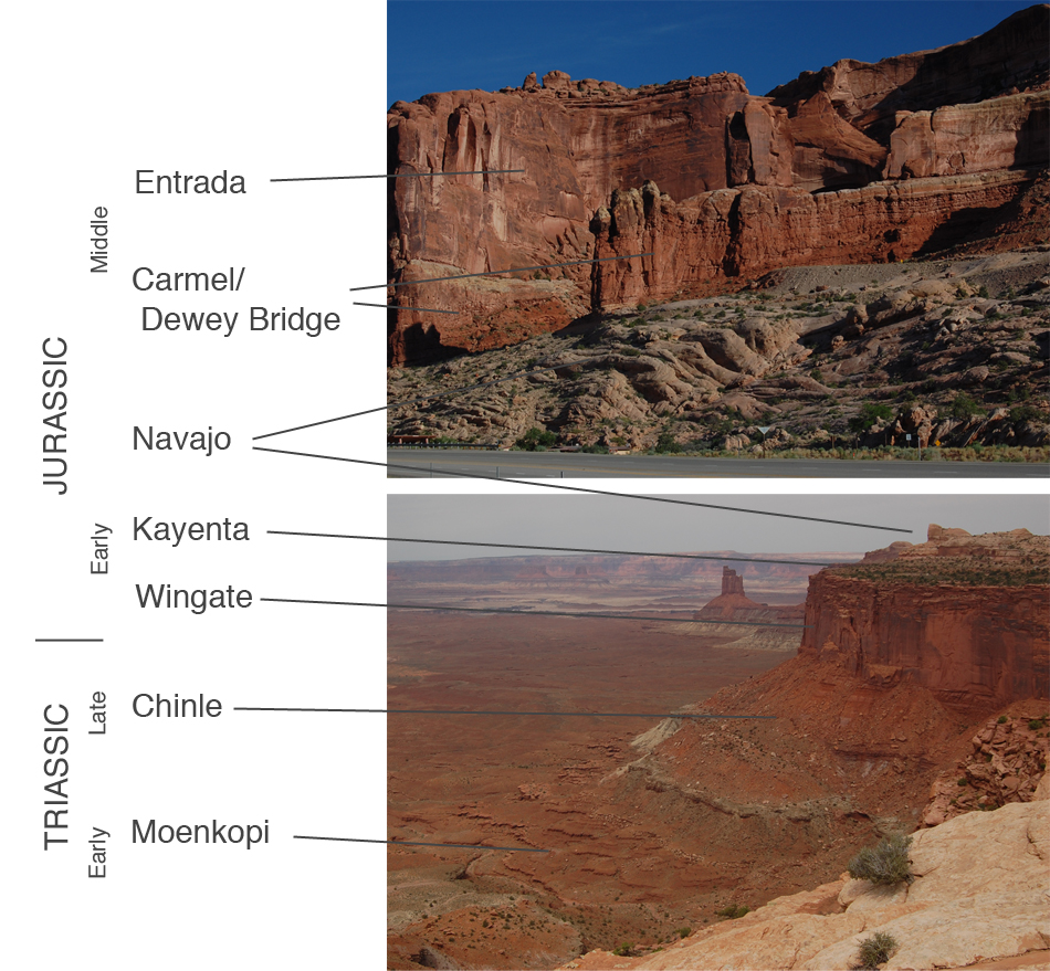
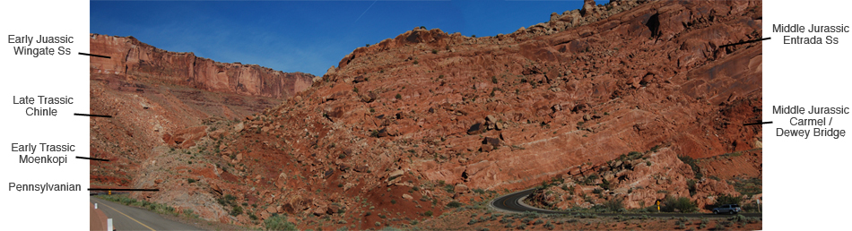
        This virtual field trip takes us to the Moab Fault, which runs essentially north-to-south just west of Moab, in east-central Utah, and just west of Arches National Park.

        Because the local stratigraphy will be significant here, let's begin with an overview of the stratigraphic units commonly seen in the area.  The image below shows these stratigraphic units with the topographic expression that they usually display, most notably with the Wingate and Entrada sandstones forming cliffs:

Image 1

Map of North America
Image 2
Local Stratigraphy
 

        As geographic background, here's a satellite image of the valley in which Moab sits.  The zone labeled "Moab Valley" here might be considered two valleys on the same axis that are joined by a narrows in the yellow circle.  U.S. Highway 191 runs down that axis of this, or these, valleys.  We'll focus on the area in the yellow circle.

Image 3
Satellite image
 

        With that bit of background, let's look at the situation with a view looking north from the north end of the town of Moab.  Take a look and make your own inferences before reading further.

Image 4
View from north end of Moab
 

        The image above is perhaps most striking in its asymmetry on each side of a central low.  On the left, the skyline consists of steep cliffs of the Wingate Sandstone, with regular slopes below.  On the right, the landscape looks much different, and in the middle is a low at the north end of the Moab valley.  U.S. Highway 191 and a Union Pacific rail line pass through that low area.

        So what does that asymmetry mean?  Just the contrasting landscapes on opposite sides of a valley would suggest a fault to many geologists, with the valley hypothesized to be the result of preferential erosion of rocks ground up in the fault.

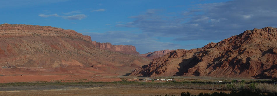
        Let's continue our reconnaissance with a view from the north, looking at the same area but from a height on Gemini Bridges Road about seven miles north of Moab.  Again, take a look and see what you see, before reading further.

Image 5
View from Gemini Bridges Road
 

        The image shows much the same as the previous one.  Now the Wingate cliffs are on the right in this view looking southwards, and the lower more irregular landscape to the east is to the left of the central low.  In the distance are the Lasal Mountains, not relevant to our present investigations but a magnificent backdrop.

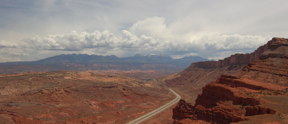
        Again, the difference in landscapes on opposite sides of a valley at least raises the possibility of a fault.  The area on the left side is largely Arches National Park.  Let's go into the park for a west-looking view from along the Park's road climbing up from the Visitor Center:

Image 6
View from Arches National Park
 

        In the image above, we're standing on the light brown Navajo Sandstone, and to the right we see the darker-brown Dewey Bridge and Entrada Sandstone rising above the Navajo.  To the left of the highway, one goes upwards from Pennsylvanian sandstones by the highway to the aforementioned cliffs of the Wingate Sandstone.  So is there a fault here?  We'll pause while you decide.  Feel free to look back to Image 2 as needed.


. . .


        . . .


                . . .


                        . . .


                                . . .


                                        . . .

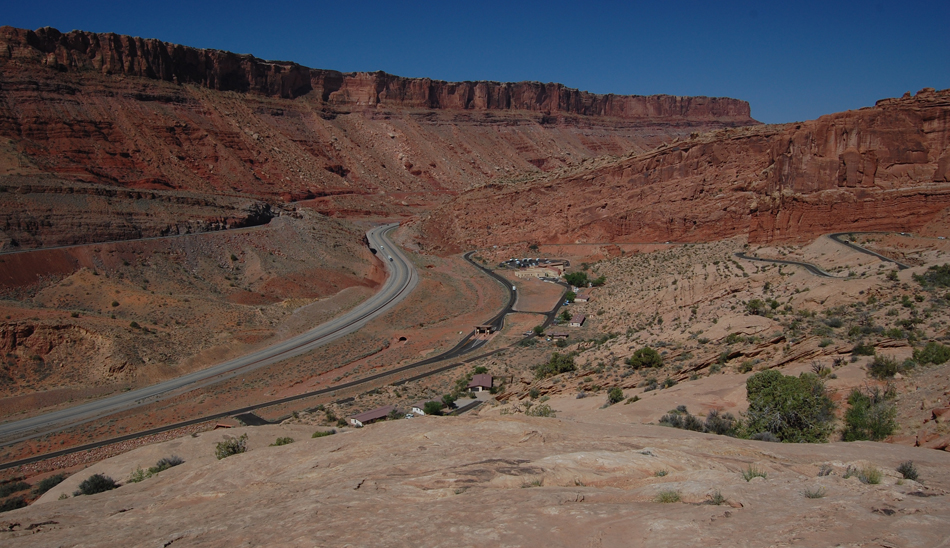
        At this point, it should be apparent that there is a fault in the vicinity of the highway, because the Navajo-DeweyBridge-Entrada sequence would sit atop the Wingate cliffs in an undisturbed succession.

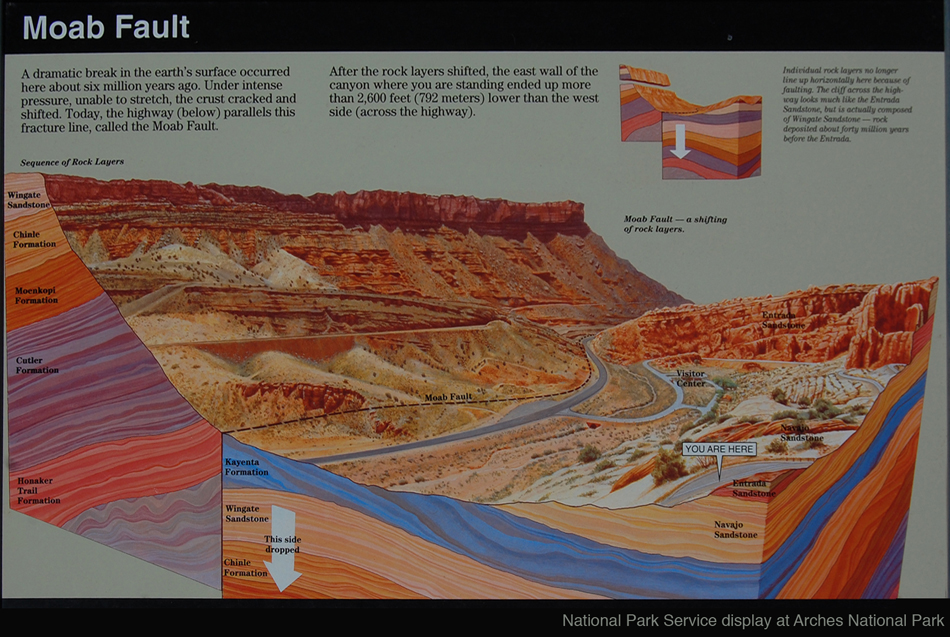
        The Park Service has a nice sign illustrating all this from the same perspective as the image above, so that the image above was captured from the "you are here" point in this sign:

Image 7
National Park Service sign
 

        The Park Service's sign nicely illustrates the idea of a fault that has put the younger Navajo-DeweyBridge-Entrada sequence lower than the older Wingate-topped sequence.  Later on we'll come back to quibble about this sign's exact placement of the fault along the highway, but the sign is certainly a good start at explaining what's going on.

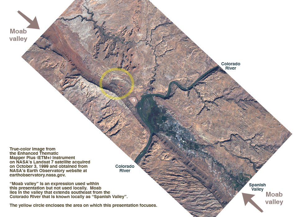
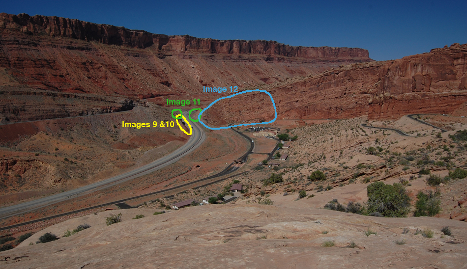
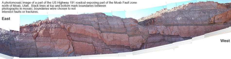
        Of course, as geologists, we would like to see the fault up close, and the exposures along the highway should be a good place to do it.  (On a virtual field trip, two bad things don't happen: no one gets run over on the highway, and the state police don't come to call.)  Let's go down to look at the south side of the highway's roadcut, in the area circled in yellow on the image below:

Image 8
View from Arches National Park, marked
 

        The image below shows the exposure along the highway.  For a more detailed view, you can use the link to the much larger version of the same image.

Image 9
Exposure of small faults along US 191
You can also view a 2716-pixel-wide 700-pixel-high version of the 950-pixel-wide 245-pixel-high image above.  It will open in a new window, so you won't have to reload this page to get back.  You'll probably have to scroll from left to right on the large version of the image.
 

        We're looking at strata in the Pennsylvanian Honaker Trail Formation, which puts us at the base of the sequence that comes down from the cliffs of Wingate Sandstone on the west side of the highway . These strata are clearly cut up not just by one fault but by a series of faults.  Peruse the image(s) for a while and decide to which direction (left-east or right-west) strata have been down-dropped along these faults.


. . .


        . . .


                . . .


                        . . .


                                . . .


                                        . . .

        Your examination has, we hope, revealed that most of these faults have dropped strata down to the right, and thus to the west.  One fault, in the right-center of the image and below the gully on the skyline, goes the opposite and drops strata down to the left, and thus to the east.

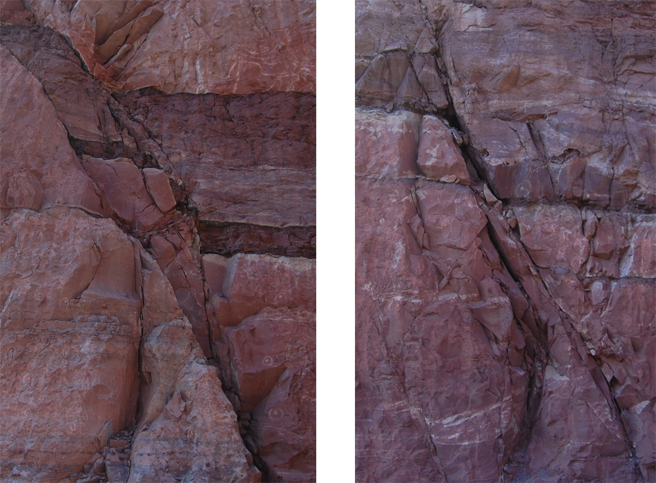
        These faults have been the subject of considerable study because of their good exposure (e.g., Foxford et al., 1998; Eichhubl et al., 2009).  In part that's because faults can be avenues for migration of petroleum through Earth's interior.  For example, the image below shows some of the space opened up along these faults where brittle rocks (mostly sandstones) have been fractured:

Image 10
Fracture duplex
 

        However, in our efforts to understand the Moab Fault as a whole, this spectacular exposure hasn't helped much.  These faults largely drop strata down to the west, whereas the big picture is that the east side of the valley has gone down (or the west side up) to put the Entrada below the much older Wingate.  Also, these faults show only a few meters of net displacement, whereas the entire fault has offset strata by hundreds of meters.  Clearly, we haven't found the heart of the fault yet.

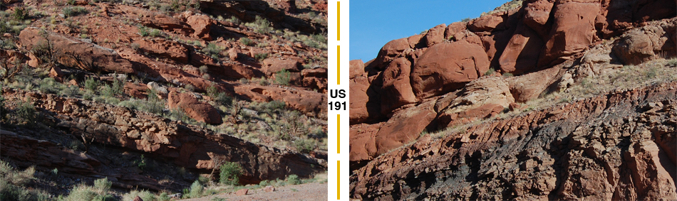
        We've been looking at the spectacular exposure of small faults in the Honaker Trail Formation on the south side of U.S. 191, but maybe we should look at the north side of the highway.  If we look west and compare the two sides of the road, it's evident that the same strata are exposed on both sides of the highway (and thus the Park Service's sign can't be correct in claiming that the fault follows the highway here):

Image 11
Two images on each side of highway
 

        If we now swing our north-looking view to the east, the image below is what we see.

Image 12
Arches side of highway
You can also view an unmarked 2031-pixel-wide 700-pixel-high version of the 950-pixel-wide 327-pixel-wide image above.  It will open in a new window, so you won't have to reload this page to get back.  You'll probably have to scroll from left to right on the large version of the image.
 

        The left side of the image above shows the Pennslvanian - to - Lower Jurassic succession, and the right side shows the Middle Jurassic succession.  In between is a reddish and very rubbly mess.  Here we've found the true Moab Fault - the surface across which several hundred meters of displacement has offset the west side of the Moab Valley higher and the east side lower.

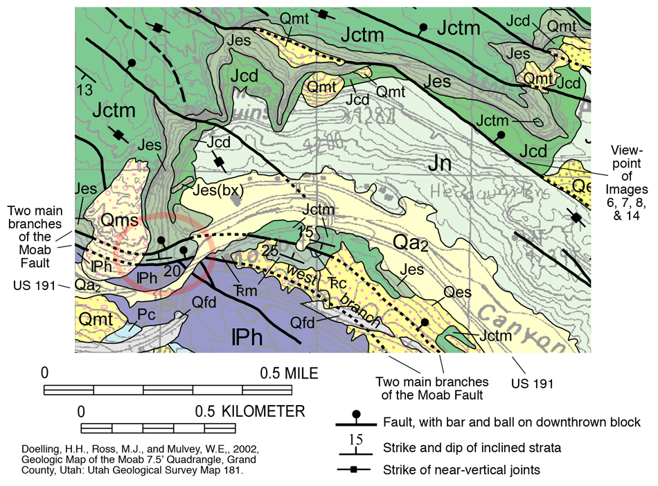
        This interpretation of the fault is that of Doelling et al. (2002) on their geologic map of the Moab Quadrangle, with the refinement that they split the fault into two branches, one on each side of the red rubble of Entrada.  Here's the relevant bit of their map, with solid lines and "bar-and-ball" symbols (in the red circle at lower left) marking each side of our rubbly zone:

Image 13
Geologic map
 

        Now, we can go back to our image of the Park Service's still very nice but not-quite-accurate sign and doodle in a correction with bold black marks:

Image 14
Park Service Sign, with editing
(If you go to Arches National Park, DON'T deface their sign with these marks!)


        So what do we get out of all this that we can generalize to other situations?  Here are some possibilities:

1) Long straight valleys that separate regions with contrasting landscapes can suggest the hypothesis of a fault (Images 3 to 6).  That hypothesis can then be tested by looking for differences in lithology or stratigraphy across the boundary, or by looking for more direct evidence of the fault itself, such as a breccia or fault gouge.

2) Most major faults are really a zone of several faults, as was the case here (Images 9 and 12).

3) The most obvious fault surfaces may not be the most significant surfaces in terms of overall motion of rock.  That was certainly the case here, where the obvious surfaces (Image 9) caused the person drawing the Park Service's sign (Image 7) to not recognize the actual surface(s) of major motion (Images 12 and 14).

4) Brecciated fault surfaces in brittle rocks can provide space for migration of fluids, such as petroleum (Image 10).

5) However, the fault surface or surfaces of most motion may be so deformed and pulverized that they are not the avenues for fluid migration (Image 12).  Instead, the surrounding fault surfaces and fractures of lesser significance to displacement (Image 9) may be the zones along which open volumes are preserved to allow migration of fluids.

. . . . and we hope you've enjoyed this trip!


____________
Bibliography:

Doelling, H.H., Ross, M.J., and Mulvey, W.E, 2002, Geologic Map of the Moab 7.5' Quadrangle, Grand County, Utah: Utah Geological Survey Map 181.

Eichhubl, P., Davatzes, N. C., and Becker, S. P., 2009, Structural and Diagenetic Control of Fluid Migration and Cementation along the Moab Fault, Utah: AAPG Bulletin, vol. 93, no. 5, p. 653-681.

Foxford, K.A., Walsh, J.J., Watterson, J., Garden, I.R., Guscott, S.C., and Burley, S.D., 1998, Structure and content of the Moab Fault Zone, Utah, USA, and its implications for fault seal prediction: Geological Society, London, Special Publications, v. 147; p. 87-103.

U.S. Geological Survey, 2006, Lexicon of Colorado Plateau Stratigraphy: 3dparks.wr.usgs.gov/coloradoplateau/lexicon/ .


Back to The main page for Railsback's virtual field trips

Back to Railsback's main page

Back to the UGA Geology Home Page